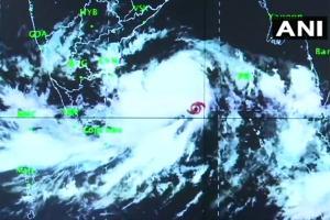
The Met office also said that the sea condition will be very rough in the west-central Bay of Bengal during May 1-3 and in the northwest Bay of Bengal during May 2-4

Pic courtesy/Twitter/ANI
New Delhi: Cyclone 'Fani' intensified into a "very severe cyclonic storm" on Tuesday and is headed towards the Odisha coast, the India Meteorological Department (IMD) said. "The severe cyclonic storm 'Fani' over the southeast and adjoining the southwest Bay of Bengal has moved north-northwestwards with a speed of about 16 kmph, intensifying into a very severe cyclonic storm," the IMD said in its bulletin.
ADVERTISEMENT
Odisha, Special Relief Commissioner, Bishnupada Sethi on preparedness for cyclone #FANI: IMD has predicted cyclone is likely to hit Odisha coast in Puri district on 3rd May. All district collectors have been alerted. All cyclone centres are being kept ready. pic.twitter.com/7BWehMIG1r
— ANI (@ANI) April 30, 2019
"It is very likely to intensify further into an extremely severe cyclonic storm during next 36 hours. It is very likely to move northwestwards till May 1 evening and thereafter recurve north-northeastwards towards the Odisha coast," it said. On Monday, the Odisha government directed the State Disaster Management Authority (SDMA) to keep a close watch over the situation and asked departments concerned to stay prepared to deal with any eventuality.
According to the IMD, light to moderate rainfall is very likely over Kerala, north coastal Tamil Nadu and south coastal Andhra Pradesh during next 24 hours. "Gale wind speed reaching 100-110 kmph gusting to 125 kmph is prevailing over the southeast and adjoining the southwest Bay of Bengal. It is very likely to increase gradually becoming 120-130 kmph gusting to 150 kmph over the southwest and adjoining the southeast Bay of Bengal from today morning," according to the bulletin.
Cyclone #FANI moved north-northwestwards with a speed of 16 kmph in last 6 hours,intensified into a Severe Cyclonic Storm&lay centred over Southeast & adjoining Southwest Bay of Bengal,about 770 km east-southeast of Chennai & 900 km south-southeast of Machilipatnam,Andhra Pradesh pic.twitter.com/WpUENYjC6b
— All India Radio News (@airnewsalerts) April 29, 2019
The sea condition is very rough in the southeast and adjoining the southwest Bay of Bengal, the IMD said, noting that it is likely to become phenomenal in the southwest and adjoining the west central Bay of Bengal, off north Tamil Nadu, Puducherry and south Andhra Pradesh coasts from today morning. The Met office also said that the sea condition will be very rough in the west-central Bay of Bengal during May 1-3 and in the northwest Bay of Bengal during May 2-4.
Indian Navy: Naval aircraft are also standing by at Naval Air Stations INS Rajali at Arakkonam, Tamilnadu & INS Dega at Visakhapatnam, Andhra Pradesh to undertake reconnaissance, rescue, casualty evacuation and air drop of relief material to the stranded if required. #CycloneFani https://t.co/rmg8kKtvk8
— ANI (@ANI) April 30, 2019
Heavy rainfall is expected at a few places over coastal Odisha and adjoining districts of north coastal Andhra Pradesh on May 3 and 4. The IMD has advised fishermen not to venture into deep sea areas of southeast Bay of Bengal and adjoining Equatorial Indian Ocean, southwest Bay of Bengal and off the Sri Lanka coast.
Catch up on all the latest Crime, National, International and Hatke news here. Also download the new mid-day Android and iOS
Edited by mid-day online desk with inputs from Agencies
 Subscribe today by clicking the link and stay updated with the latest news!" Click here!


